During the 6 years of the survey, Euclid will collect more more than 500,000 visible (VIS) and near infrared images (NISP imaging and NISP spectroscopy) that will be transferred to Earth on a daily basis.
The Euclid space images will be complemented by visible imaging data from ground-based telescopes, covering the same sky as the Euclid mission, in order to derive photometric redshifts (distance measurements) of lensed sources. Euclid space and ground data will provide photometry of each galaxy in 7 different filters ranging from 460 nm to 2000 nm (g,r,i and z bands from the ground, Y, J and H from Euclid) down to 24.0 to 24.5 AB magnitude. Overall, the Euclid input images represent several million of images and about 30 Petabytes of image data.
In addition to the data volume one challenge of the science ground segment is to process and analyse heterogeneous data sets that mix together space and ground based images.
About 10 billion sources will be observed by Euclid, out of which more than 1 billion will be used for weak lensing, and about 30 million galaxy redshifts will be obtained. The science ground segment is a most challenging part of this mission and represents about 50% of the resources provided by the Euclid Consortium. The ground segment activities are shared between ESA and the Euclid Consortium.
The Science Ground Segment (SGS) of the Euclid mission is composed of the combination of two independent sections: the ESA Science Operations Centre (SOC), and the Euclid Consortium Science Ground Segment (EC SGS). SOC will be the single interface to the ESA Mission Operations Centre (MOC), and hence to the Euclid Operations Ground Segment (OGS). The SOC is also in charge of the survey planning, managing the downlinked data (i.e. performing quick look, daily quality reports and telemetry editing) and providing the EC with the data necessary to perform further processing of the science data.
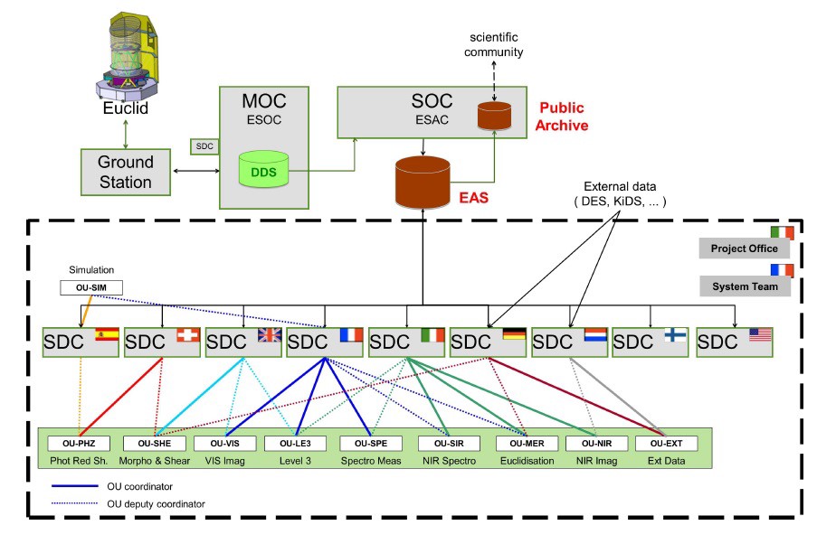
Organisation of the Science Data Centers (SDC) under responsibility of the Euclid Consortium. The SDC are computing centers in charge of running the data processing pipelines. Credit: Euclid Consortium/ESA/SGS Team.