SST Project (Space Surveillance and Tracking)
Currently, in geocentric orbit, there are 4070 operational satellites and 2900 no longer functional. To these almost 7,000 objects must be added space debris (“space debris”, as they are called in Europe, or “space junk”, as the Americans prefer to call them), formed by rocket stages used for placing the satellites and fragments deriving from the explosions of the engines or from the collisions already occurred in orbit. It is estimated that, since the launch of Sputnik 1 on October 4, 1957, there have been approximately 560 fragmentation events in orbit. The number of space debris with known geocentric orbits is approximately 28,000, but this is not the number of the entire population.
The smallest fragments escape the detection of ground radars and telescopes. It is necessary to resort to statistical methods to have an estimate of the total population of objects: a bit like one does to estimate the total number of the population of near-Earth asteroids: from the observable ones, the power law that governs them is deduced and the dimensions that are not visible are extrapolated. Estimates show 34,000 space debris with dimensions greater than 10 cm, while those with dimensions in the range 1 – 10 cm rise to 900,000 and those in the range 0.1 – 1 cm to 128 million. As can be seen, circumterrestrial space is very crowded: space debris can be a serious problem for the operational life of satellites and space navigation.
In practice, the circumterrestrial space is populated by a “cloud” of uncontrollable artificial objects, the number of which increases more and more, both due to new launches and as a result of reciprocal collisions, which – even if they occur rarely – increase exponentially the number of smaller fragments in orbit. On the other hand, the population of operational satellites is destined to increase rapidly in the coming years, just think of the periodic placing into orbit of the satellites of the Starlink constellation, made up of 12,000 satellites of the US company SpaceX to bring broadband to every corner of the planet. Hence the need to minimize the impact risk between satellites and space debris through rigorous and continuous monitoring of their orbits. All orbits of artificial satellites are geocentric and are classified according to their altitude on the Earth’s surface.
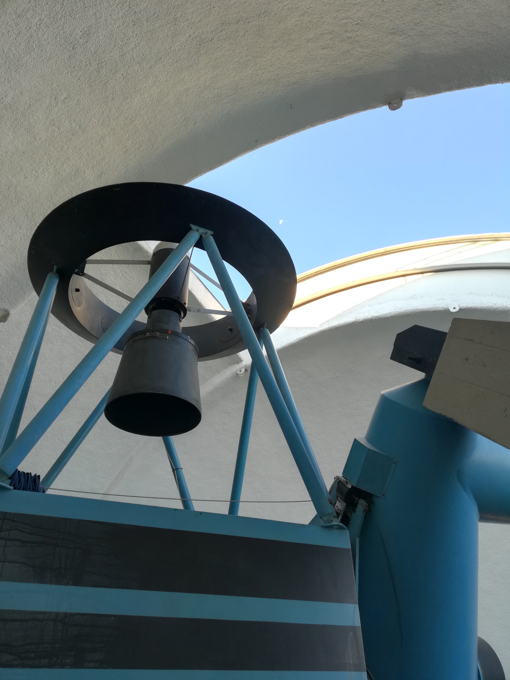
The “G. D. Cassini” telescope of the INAF-OAS observation station of Loiano is a Ritchey-Chrétien type reflector with a main mirror diameter of 1.52 meters and a weight of 9 tons. The instrument is housed inside a hemispherical dome 12 meters in diameter.
Types of orbits for artificial satellites
All the orbits of artificial satellites are of the geocentric type, i.e. they have the centre of the Earth as their centre of force. Low orbits (or LEO, Low Earth Orbit) are considered those above 160 km and below 2000 km, where the friction of the Earth’s atmosphere is still felt. For example, the ISS and the Hubble Space Telescope are examples of satellites in LEO. Typical orbital periods of LEO satellites range from 88 to 120 minutes. The satellites at about 36,000 km of altitude are in geosynchronous orbit (or GEO, Geosynchronous Earth Orbit), i.e. the orbital period is identical to the Earth’s rotation period: 23h 56m 04s. If the inclination of the orbit on the plane of the earth’s equator is zero, then these satellites remain fixed in the sky with respect to the observer (but not to the celestial sphere) and are called geostationary. Typical geostationary satellites are those for telecommunications. The satellites with an orbit between LEO and GEO are MEOs (Medium Earth Orbit), with orbital periods between 2 and 24 hours. If the MEO is elliptical, the satellite will be forced to pass within the Van Allen belts, which can be a problem for the onboard electronics. The Van Allen belts are toroids of charged particles (electrons and protons), trapped by the Earth’s magnetic field due to the Lorentz force. The internal Van Allen belt extends between 1,000 and 6,000 km of altitude, and the external one between 14,000 and 19,000 km. Due to the presence of these two bands, the MEO orbit area is sparsely populated. Typical MEO satellites are used for navigation, communications and geodesics. The most common altitude is just above the outer Van Allen belt, at about 20,200 km, corresponding to an orbital period of 12 hours. This orbit is used, for example, by satellites of the United States GPS (Global Positioning System). Due to the low energy required for launch and the possibility of observing the Earth’s surface in the finest details, the most used type of orbit is LEO: this is the region of space most crowded by scientific, military, meteorological and navigation.
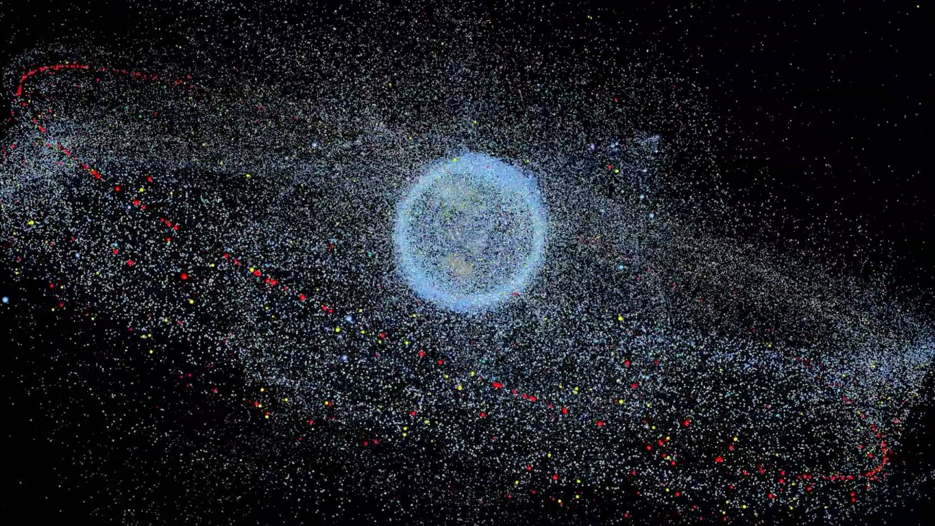
The distribution of space debris in orbit around the Earth (ESA).
The EUSST consortium
At the European level, military security, and the protection of economies, societies and citizens are based on applications of space technologies such as communication, meteorology, soil analysis and satellite navigation. However, due to the growing complexity of the circumterrestrial orbital environment, space assets are increasingly at risk of collision with other satellites, whether operational or not (space debris). At the same time, orbiting objects can re-enter the atmosphere and cause damage to the ground. Mitigating these risks requires the ability to measure the position of satellites/space debris and determine their geocentric orbit. This information is essential and can be shared with interested companies/entities. To this end, the European Union established support for Space Surveillance and Tracking (SST) in 2014 by creating an SST consortium supported by five EU Member States (France, Germany, Italy, Spain and the United Kingdom). It expanded in 2018 to eight states with the addition of Poland, Portugal and Romania. Space surveillance activity refers to the ability to detect, catalogue and predict the trajectories of space objects orbiting the Earth.
Since 2016, the SST Consortium and the European Union Satellite Center have been working together to develop a European SST capability in a series of EU-funded projects, known as ‘EUSST’. The EU Member States of the SST consortium have designated National Operational Centers to provide operational SST services to users via the EUSST Service Portal. Users are provided with three types of services:
1) Flyby analysis: The risk of collision between satellites or between spacecraft and debris is evaluated to generate collision avoidance warnings during all phases of the mission.
2) Reentry Information and Analysis: Assess the risk of uncontrolled re-entry of objects and debris into the Earth’s atmosphere and generate related information, including estimated timescale and probable location of possible impact.
3) Fragments in orbit: Detection and characterization of fragmentations, breakups or collisions in orbit.
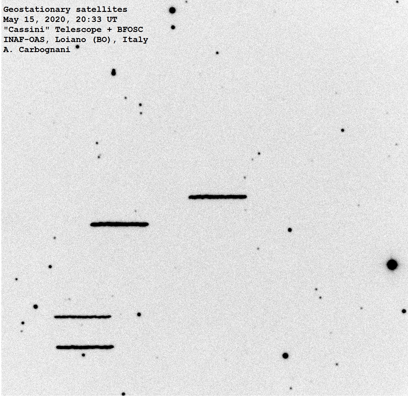
A group of geostationary satellites imaged with the CCD camera of the “Cassini” telescope on May 14, 2020. The telescope was tracking the celestial sphere at sidereal speed and this determined the “blur” of the satellite tracks which are fixed with respect to the celestial sphere.
Space Surveillance and Tracking capabilities are considered strategic by Italy and fall within the remit of the Ministry of Defense which, with ISOC (Italian SST Operational Centre), at the Air Force Base in Pratica di Mare (RM), manages the data flow of optical telescopes and radar observations of the entire Italian EUSST network, interfacing and coordinating with the European space surveillance network. The characteristics of duality and integration of the defence systems with the devices made available by civil research agencies and bodies such as ASI (Italian Space Agency) and INAF (National Institute of Astrophysics) allow the Italian SST architecture to make use of various types of sensors (radar, laser and optical) distributed throughout the country.
OAS contribution to EUSST
In OAS a part of the observation time of the “G. D. Cassini” telescope of the Loiano observation station is dedicated to the astrometric observations of satellites/debris species in close collaboration with ISOC. With its 1.52 meters in diameter of the main mirror, the “Cassini” allows you to reach a magnitude limit of about +22 with prolonged exposures. It is the second-largest telescope in Italy and the most sensitive among the European optical telescopes dedicated to Space Surveillance. Thanks to its remarkable performance, within the EUSST Consortium, “Cassini” is used to image the smallest and most distant objects from the Earth, mainly in the “high” orbital bands, i.e. GEO and MEO. Considering the high speed with which artificial satellites move (from about 8 km/s for LEOs to 3 km/s for GEOs), the “Cassini” has been equipped with a new GPS system to measure the time of satellite image retrieval. The images and astrometric measurements obtained in OAS are sent to the EUSST database and used to calculate the orbital elements of the satellites in the TLE (Two-Line Elements) format, which is necessary to implement the services provided by EUSST itself. OAS has developed both ad hoc software for the calculation of the satellite/space debris ephemeris used to point the telescope (“TLE2Ephemeris”) and software for the astrometric measurement of the satellite/space debris positions on the CCD images (“SST2TDM”). Obtaining good astrometric measurements – i.e. positions with an average residual of the order of arc second – is crucial in this field, otherwise, it is impossible to determine the orbit of the satellite/space debris with an accuracy acceptable for the services provided by EUSST.
Future perspectives
The telescope will soon be further enhanced with the construction of a wide-field CCD camera (SuperFOSC project, or Super Faint Object Spectroscopic Camera), capable of extending the observed field of view, also allowing spectroscopic and polarimetric analysis of the observed targets. Furthermore, the support of the “Cassini” is foreseen, with a series of new instruments under construction and dedicated explicitly to space surveillance. In this context, a battery of smaller and more manageable telescopes is being built (TANDEM project, Telescope Array and Nabling Debris Monitoring), capable of extending observations also to fast space debris, in lower orbits, thanks to the field of view considerably wider than that of the “Cassini”.
On even greater fields of view, virtually “all-sky” (but obviously with a lower sensitivity level of the detections), the national network of all-sky cameras (ASTRA project, All-Sky Tracking Array) will be remotely operated from Loiano it will be able to observe all the larger (and therefore more dangerous) objects flying over the Italian territory on “low” orbits, in the pre-re-entry phase into the atmosphere. These observations will make it possible to determine the orbital regime and the possible risk profile of these objects in the event of a fall on our territory, information of direct interest to the National Civil Protection Department. The cameras of the ASTRA network will be very useful in the case of uncontrolled re-entries, such as that of the large Chinese space laboratory Tiangong 1, weighing over 10 tons, which fell to Earth on April 2, 2018.
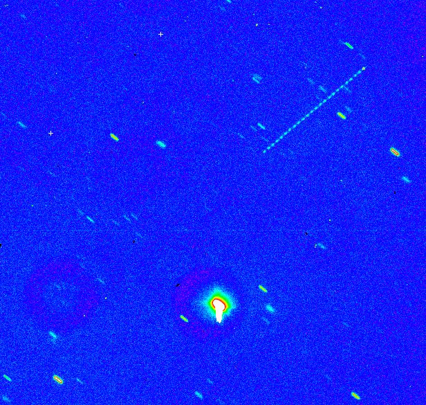
Very remote space debris. This is the last stage of the Chinese Long March 3 missile, which transported the Chang’è 2 probe into lunar orbit in 2010. After giving the last thrust to the spacecraft, the carrier stage remained “trapped” on a highly elliptical orbit, making the “rubber band” between the Earth and the Moon approximately every twenty days, until its final return to the atmosphere. In this CCD image, the missile stage is seen from Loiano with the “Cassini” telescope, on December 26, 2016. The object, cylindrical in shape, proceeded “tumbling” along its trajectory and this generated the “dashed” luminous trace -line” visible at the top right.
Conclusions
The complexity of the SST project and the multiple service and research activities involved require a broad spectrum of technical-scientific skills and a large research group, currently the largest within OAS. In total, about fifteen people are involved at various levels in the project, including a growing fraction of young people in carrying out thesis or professional training projects on these spatial issues.